Disko Island
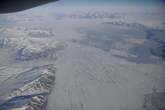

Here's a great series of images from Flickr user coastal eddy, whose photostream boasts an impressive array of aerial images. This series comes from West Greenland, in the vicinity of Disko Island, Greenland's largest offshore island. The first shot shows the Nordost Bay, north of Disko. On the left is the southern portion of the Svartenhuk Peninsula, and above right center is the Ingia cape at the northern tip of Ubekendt Island.
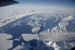
 Photo (© coastal eddy)
View on Flickr

 Google Earth Screenshot
View in GE
Suvdlorssuaq Strait, West Greenland
This image shows the Suvdlorssuaq Strait between Disko Island (right) and the Nuussuaq peninsula of the mainland (on the left). Note the huge ice floes.
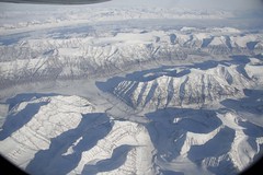
Photo (© coastal eddy)
View on Flickr

Google Earth Screenshot
View in GE
Kuganguaq Valley, Disko Island, West Greenland
The final image shows the Kuganguaq Valley on Disko Island, looking north across the Suvdlorssuaq Strait with the Nuussuaq peninsula visible in the background.
Photos taken: March 14, 2006
Photos by: coastal eddy
Route: Unknown