Düsseldorf to Vancouver


Flickr user banthafood posted this extensive series of images from Greenland and Canada back in July. The full series contains over 100 images; I've only located a portion of them here, since there are quite a few shots of meltwater lakes, icebergs, and other transient phenomena. The first section features images from East Greenland, starting with this shot of the Gåsefjord (the fjord running through the center of the image). The Gåsegletscher glacier winds through the image at far left, with another glacier in the foreground and to the right. Both glaciers feature very prominent medial moraines (the dark stripes in the glaciers).
Here's another view of the same pair of glaciers, taken by Flickr user jurvetson in 2005.
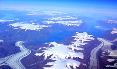
 Photo (© jurvetson)
See original post.

Photo (© banthafood)
View on Flickr

 Google Earth Screenshot
View in GE
Glacier and Gåsefjord, East Greenland
Here's a close-up look at the terminus of the right-hand glacier from the previous image, as it enters the Gåsefjord. The wide medial moraine on the left side of the glacier, consisting of rocks and debris scraped valley walls as two glaciers meet, stretches upward along the glacier for over 16 km. The medial moraine is about 150 meters wide at the point where it enters the fjord; the glacier itself is about 3.6 km wide at that point.


This image presents a close-up look at the terminus of the Gåsegletscher at the head of the Gåsefjord. This glacier is unusual in that it does not flow directly into the fjord; it tapers off a few hundred meters short of the water's edge. At its terminus, the glacier deposits large quantities of soil and debris as it melts. This debris field is pockmarked by small ponds and cris-crossed by small streams flowing into the fjord, which can be seen in the high-resolution version of this image.


A little further up the Gåsegletscher, this image provides a good view of how the medial moraines are formed at the Y-shaped intersection of two smaller glaciers flowing into the image from the left and bottom of the frame. The debris carried along the sides of each smaller glacier merges at the intersection to form a moraine running through the middle of glacier downstream from the merger point.


This image provides a good overview of the large-scale structure of the Gåsegletscher, showing the complex system of smaller glaciers merging together and flowing toward the fjord at right-center.

Photo (© banthafood)
View on Flickr

Google Earth Screenshot
View in GE
Vestfjord Glacier, East Greenland
About 40 km west, the next image shows the upper reaches of the Vestfjord Glacier. Two glaciers are merging at the bottom of the frame, and another is entering from the left. Near the center of the image are a pair of bright blue meltwater lakes; these form on the surface of glaciers and icecaps in some areas, and can persist for long periods of time.

Photo (© banthafood)
View on Flickr

Google Earth Screenshot
View in GE
Vestfjord Glacier, East Greenland
Here's a wider view of the Vestfjord glacier system. The previous image is a close-up of the bottom-center section of this image.


About 30 km further northwest, we have this semi-abstract image of a range of nunataks (mountains protruding through the icecap) and meltwater lakes.

Photo (© banthafood)
View on Flickr

Google Earth Screenshot
View in GE
Paul Stern Land, East Greenland
The final East Greenland image in this series is view looking northeastward toward the coastline, showing the waters of the Denmark Strait in the distance, and the area known as Paul Stern Land near the center of the image.
Photos taken: July 22, 2007
Photos by: banthafood
Route: Düsseldorf to Vancouver